2021
2021 History
US National Weather Service Spokane is forecasting record daytime temperatures AND record overnight warm low temperatures this weekend into next week.
Very High Confidence of High Impact Heat this weekend and persisting through next week.
- Several communities will likely experience triple digit heat for at least 7 consecutive days.
- Overnight lows will be unseasonably warm making it difficult to control the build up of heat in homes without air conditioning.
- Numerous all-time record high temperatures are in jeopardy
- With no significant widespread rain expected anytime soon, our region will be exceedingly dry by the Fourth of July Weekend and vulnerable to fires.
- Prolonged and excessive heat will further stress drought stricken crops.
Links to library address and hours are below.
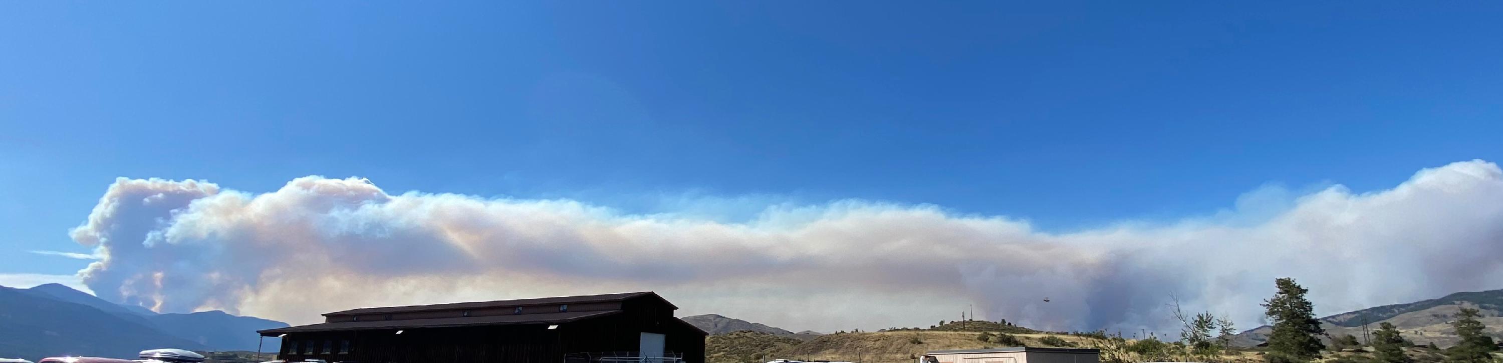
Photo: Cedar Creek Fire on Left- Cub Creek 2 Fire on Right
Taken 7-18-2021, 5 PM from the Forest Service Office in Winthrop, WA
Recording of the Community Meeting Cedar Creek-Cub Creek 2 Fires Burned Area Assessment
________________________________________________________________
July 10, 2021
1700
LEVEL 1 - Advisory
A fire is burning near Cedar Creek, Southwest of Mazama.
The USFS is actively working the fire.
The name of the fire is Cedar Creek.
A Level 1 Advisory has been issued for persons in the Mazama Area and up Lost River.
Level 1 is an Advisory, NOT an immediate Evacuation.
Persons should be aware of their surroundings and take action if needed.
Do not wait for door to door notification, take action if needed.
Level 1 Advisory, NOT an Immediate Evacuation for the Mazama Area and up Lost River.
2030
Cedar Creek Fire is still active and is now estimated to be 100 acres.
Level 1 Advisory for the Cedar Creek Fire will stay in place for the Mazama and Lost River areas overnight.
An update will be provided by 9:00 AM tomorrow morning, 2021-07-11.
Level 1 is an Advisory, NOT an Immediate Evacuation.
Persons should be aware of their surroundings and take action if needed
_______________________________________________
2021-7-11
0900
Cedar Creek Fire is still ACTIVE.
Level 1 Advisory will remain in place for the Mazama and Lost River Areas.
Early Winter Camp Ground is CLOSED.
State Route 20 is OPEN. Deployment of WSDOT reader boards in works, warning travelers of Fire personnel and possible visibility reduction due to smoke.
Aviation and Ground personnel will be working the fire today.
For any Pilots, both Airplane and SUAV, there is a TFR in place. Surface to 11,000 feet.
2021-07-11
1130
Cedar Creek Fire remains active.
A second fire “Varden” is burning a few miles to the west of Cedar Creek Fire, one half mile off of SR 20.
Due to the Varden Fire USFS has requested the WSDOT reduce SR 20 down to one lane of traffic with a pilot car, between Mile Posts 170 and 175.
Klipchuck and Lone Fir Campgrounds have been closed.
2021-07-11
1930
There are three fires burning west of Mazama in Okanogan County.
Cedar Creek and Varden Fires are south of SR 20.
The Varden Fire is closest to SR 20 and working its way towards the highway. SR 20 (MP-170 to 174) was reduced down to one lane with a pilot car today, 7-11-2021, as to allow crews room to work next to the highway.
SR 20 will open back up to two lanes around 8 PM tonight until approximately 8 AM tomorrow morning when it will again be reduced down to one lane. If the fire reaches SR 20 you can expected that SR 20 would be closed.
The Delancy Fire is north of SR 20 and being estimated at 30 acres.
Level 1 Advisory is still in effect for the Mazama and Lost River areas.
This is a good time for persons in the Level 1 area to make a plan for “If we get EVACUATED”.
Let’s hope it does not get to that point, but if it does, you should be prepared.
Update will be provided 7-12-2021 when information becomes available.
_______________________________________________________
2021-07-12
1000
State Route 20 CLOSED at 10:00 today 7-12-2021 until further notice between Mile Post 170.6 on the west end and Mile Post 177.4 on the east side.
Varden Fire has not reached the SR20 but due to personnel and equipment on the roadway it was closed.
Level 1 Advisory remains in effect for the Mazama and Lost River areas.
Link to WSDOT:
WSDOT - Washington State Travel Alerts
___________________________________________________
July 13, 2021
1355
Level 1 Advisory is still in effect for the Mazama and Lost River areas.
Northwest Type II Interagency Incident Management Team #8 took over management of the fires at 6:00 a.m. July 13.
The team is in process of establishing a phone line for additional information and setting up information boards.
The next fire information update will come out from the team this evening. We appreciate your patience during this transition period.
A Facebook page: https://www.facebook.com/MazamaFires2021 and
InciWeb page: https://inciweb.nwcg.gov/incident/7655/
have been established for the fires.
State Route 20 North Cascades Highway remains closed to all traffic due to fire activity between milepost 170 and 177 is closed approximately 20 miles west of Winthrop between Silver Star and Early Winters).
There is no estimated time for reopening of the road.
____________________________________________________
July 14, 2021
0853
LEVEL 2 Be ready is being issued for all persons living south of the Methow River and west of Lost River Road (Mazama entrance).
Level 2 is being issued due to the Cedar Creek and Varden Fire Activity.
Level 2 Be Ready, you must be prepared to leave at a moments notice.
Persons should be aware of their surroundings and take action if needed. DO NOT wait for door to door notification, take action if needed
Level 1 remains in effect for persons living north of the Methow River, up Lost River Road and east of Lost River Road (Mazama entrance) to the intersection of Goat Creek Road and SR 20.
State Route 20 North Cascades Highway remains closed to all traffic due to fire activity between milepost 165 and 177.4 (closed approximately 20 miles west of Winthrop between Silver Star and Early Winters).
______________________________________________________
A Public Meeting has been scheduled for Thursday, July 15, 2021 at 6:00 PM at the Mazama Store courtyard. The fire managers will provide updates on the fires and an opportunity for the public to ask questions. Managers will remain after the presentation and Q&As for individual questions and different displayed maps.
_______________________________________________________
July 18, 2021
2056
The Cub Creek 2 Fire in Winthrop Washington and the Cedar Creek - Delancy Fires in Mazama Washington experienced growth today. Smoke columns were visible on both fires. After receiving numerous calls from concerned residents regarding our current evacuation levels, we have evaluated the current evacuation levels and determined that they will remain unchanged for both the Cub Creek 2 Fire and the Cedar Creek - Delancy Fires. We are asking that residents respect the road closures that are in place as they are meant to protect you from potential harm. Please remain aware of your surroundings and be prepared should we need to increase our evacuation levels at a moments notice.
As of today July 18, 2021 ALL Evacuations remain the same.
_____________________________________________________
2030
A Level 2 (BE READY) has been issued for persons living from the end of Lost River Road to Mazama then east 2.5 miles towards Winthrop on Goat Creek Road to Mile Post 3. This area is all on the North side of the Methow River.
Persons should be aware of their surroundings and take action if needed.
You must be prepared to leave at a moments notice.
This may be the only notice you receive.
Do not wait for door to door notification, take action if needed.
A Level 1 (Advisory), remains in effect for persons living in the area from the intersection of Sate Route 20 and Goat Creek Road west 3 miles towards Mazama to Mile Post 3 on Goat Creek Road and from the intersection of State Route 20 and Goat Creek Road west 3 miles to Mile Post 182 at the Mazama Bible Camp Road, on State Route 20.
______________________________________
1844
A Level 3 Immediate Evacuation (GO NOW) has been issued for the area on the State Route 20 side of the Methow River from the Mazama entrance (Lost River Road) east towards Winthrop to the Mazama Bible Camp Road. (SR 20 from Mazama to Mile Post 182)
Evacuations are due to increased fire activity of the Cedar Creek Fire, burning Southwest of Mazama Washington
Persons should be aware of their surroundings and take action NOW.
Be cautious of emergency vehicles responding.
This may be the only notice you receive.
Do Not wait for door to door notification, take action NOW. Evacuate towards Winthrop NOW.
State Route 20 is CLOSED west of Mile Post 182 (Mazama Bible Camp Road).
A Red Cross Shelter is in Stand-by status at the Methow Valley Elementary School in the Eagle Gym. Please call 509-670-5331 to contact the shelter.
For Fire Information call: 509-557-0740
___________________________________________
1419
A Level 3 Immediate Evacuation (GO NOW) has been issued for the area on the State Route 20 side of the Methow River and west of the Mazama entrance (Lost River Road), which includes:
Arrow Leaf Road
Cassal Ranch Road
Early Winter Drive
Freestone Inn Drive
Freestone Lake Drive
Mazama Pines Lane
Wilson Ranch Road
Due to increased fire activity of the Cedar Creek Fire, burning Southwest of Mazama Washington.
Persons should be aware of their surroundings and take action NOW.
Be cautious of emergency vehicles responding.
This may be the only notice you receive.
Do Not wait for door to door notification, take action NOW. Evacuate towards Winthrop NOW.
State Route 20 is CLOSED at Lost River Road, entrance to Mazama.
A Red Cross Shelter is in Stand-by status at the Methow Valley Elementary School in the Eagle Gym. Please call 509-670-5331 to contact the shelter.
For Fire Information call: 509-557-0740
View Area on MAP: There is no estimated time for reopening State Route 20.
A Facebook page: https://www.facebook.com/MazamaFires2021 and
InciWeb page: https://inciweb.nwcg.gov/incident/7655/
have been established for the fires.
Link to WSDOT:
WSDOT - Washington State Travel Alerts
Fire Information Number 509-557-0740
Red Cross Shelter 509-670-5331
***There is a stand-by shelter located at the Methow Valley Elementary School in the Eagle Gymnasium***
______________________________________________________
July 20, 2021
1700
Level 2 (BE READY) has been issued for all persons living north of the Methow River from the end of Lost River, east on Lost River Road to Mazama then east on Goat Creek Road to the intersection of SR 20, including the Edelweiss area.
Level 2 (Be Ready) has been issued for all persons living between State Route 20 and the Methow River from the intersection of SR 20 and Goat Creek Road east towards Winthrop to Mile Post 190.5.
Level 2 (Be Ready) has been issued for persons living off of Wolf Creek Road between the Wolf Creek Bridge and Green Road.
Level 2 (BE READY) has been issued for the Sun Mountain Lodge area.
Persons should be aware of their surroundings and take action if needed.
This may be the only notice you receive.
Do not wait for door to door notification, take action if needed.
Level 2 (BE READY) is being issued due to the increased fire activity on the Cedar Creek Fire, Mazama Washington.
Where to find official information:
FACEBOOK www.facebook.com/Okanogan.County.Emergency.Management/
View MAP of Area: https://arcg.is/09bOvm
__________________________________________________________
1529
A Level 3 Evacuate NOW has been issued for all persons living on the gravel portion of Wolf Creek Road from State Route 20 east to the pavement, Winthrop Washington.
Persons should be aware of their surroundings and take action NOW.
This may be the only notice you receive.
Do Not wait for door to door notification, take action NOW.
Level 3 Immediate Evacuation (GO NOW) is being issued due to the increased fire activity on the Cedar Creek Fire.
A Red Cross Shelter is in Stand-by status at the Methow Valley Elementary School in the Eagle Gym.
Please call 509-670-5331 to contact the shelter.
______________________________________
0052
Level 3 Immediate Evacuation (Go NOW) for persons in the area east of Mazama Bible Camp Road to Wolf Creek. Along State Route 20 from Mile Post 182 east to Mile Post 185.
Persons should be aware of their surroundings and take action NOW.
Be cautious of emergency vehicles responding.
This may be the only notice you receive.
Do Not wait for door to door notification, take action NOW.
Evacuate towards Winthrop NOW.
A Red Cross Shelter is in Stand-by status at the Methow Valley Elementary School in the Eagle Gym.
Please call 509-670-5331 to contact the shelter.
For Fire Information call: 509-557-0740
View MAP of Area:
There is no estimated time for reopening State Route 20.
A Facebook page: https://www.facebook.com/MazamaFires2021 and
InciWeb page: https://inciweb.nwcg.gov/incident/7655/
have been established for the fires.
_________________________________________________________
July 21, 2021
2310
Level 3 Immediate Evacuation (GO NOW) has been issued for persons living off Wolf Creek Road between the Wolf Creek Bridge and Green Road, including:
Aspen Lane
Green Meadows Road
Cottonwood Drive
Green Road
Lealand Road
Left Fork Wolf Creek Road
Lobus Run Road
Lodge Lane
Luck Louie Road
Perrow Drive
Sundance Lane
WC Fields Road
Wild Den Road
Wolf Ridge Lane
Wolf Song Road
Winding Road
AND Sun Mountain Lodge
Persons should be aware of their surroundings and take action NOW.
This may be the only notice you receive.
Do Not wait for door to door notification, take action NOW.
Level 3 Immediate Evacuation (GO NOW) is being issued due to the increased fire activity of the Cedar Creek Fire.
Evacuate towards Winthrop.
A Red Cross Shelter in in Stand-by status at the Methow Valley Elementary School in the Eagle Gym.
Please call 509-670-5331 to contact the shelter.
For Fire Information call 509-557-0740
___________________________________________
A Fire Information Public Meeting will be held tonight, Wednesday, July 21, 2021, 6 PM at the Mack-Lloyd Park next to the Red Barn in Winthrop.
Come get your questions answered about the Cedar Creek / Delancy Fires, and the Cub Creek 2 Fire, from the Incident Management Fire Managers, Local Fire Department, and Emergency Management.
Make sure you bring your chair. If you need a mask for the smoke, pick one up at the meeting.
Being informed is part of being prepared.
________________________________________________________
July 22, 2021
2100
View Area on the MAP
Four Level 2 Be Ready zones have been issue for the Winthrop area due to the fire activity of the Cedar Creek Fire.
ALL OTHER EVACUATION LEVELS issued due to the Cedar Creek Fire remain in effect.
Visit Okanogan County Advisory MAP to view the areas.
Level 2 Be Ready is not an immediate Evacuation, it is a Be Ready to Leave at a moments notice.
Areas are described below:
Level 2 (Be Ready) issued for the Pine Forest Development. (Name of zone - Pine Forest Development)
Level 2 (Be Ready) issued for the Moccasin Ranch area, which includes the area within, starting at the intersection if Twin Lakes Road and Wandling Road to the North on Twin Lakes Road to the Intersection of Patterson Lake Road then to Elbow Coulee Road directly to Dibble Lake. (Name of the zone - Moccasin Ranch Area)
Level 2 (Be Ready) issued for the area of the Wolf Creek starting at the Wolf Creek Bridge, east towards Winthrop along the Methow River to the Winthrop Fish Hatchery then South on Twin Lakes Road to the North end of Patterson Lake. (Name of zone - Eastern Wolf Creek)
Level 2 (Be Ready) issued for the Twin Lakes Development area, which includes an area within, starting at the end of Twin Lakes Road at the Winthrop Fish Hatchery Road, South on Twin Lakes Road to Wandling Road directly back to the Winthrop Fish Hatchery Road. (Name of the zone - Twin Lakes Development)
Persons should be aware of their surroundings and take action if needed.
You must be prepared to leave at a moments notice.
DO NOT wait for door to door notification, take action if needed.
Level 2 (BE READY) is being issued due to the fire activity on the Cedar Creek Fire, Winthrop Washington.
A Red Cross Shelter is available at the Methow Valley Elementary School in the Eagle Gym.
The number for the Red Cross Shelter is 509-670-5331.
For Fire Information call 509-557-0740
_______________________________________________________
July 25, 2021
2150
Level 3 (Immediate Evacuation) has been issued for the Pine Forest Development.
Cedar Creek Fire is near the South side of the Sun Mountain Lodge area.
Persons should be aware of their surroundings and take action NOW.
This may be the only notice you receive.
DO NOT wait for door to door notification, take action NOW.
Level 3 Immediate Evacuation (GO NOW) is being issued due to the increased fire activity on the Cedar Creek Fire.
EVACUATE TOWARDS WINTHROP.
Level 3 for all roads listed:
Bitterroot Lane
Daisy Place
Elbow Coulee Road
Lodgepole Drive
Long Leaf Lane
Mugo Road
North Blackjack Road
Nighthawk Ridge Road
Pond Road
Pumphouse Road
Red pine Cr
Rocky Top Rd
Rodeo Drive
South Blackjack
Short Leaf Road
Sugar Pine Road
Summer Road
Timber Creek Lane
Umbrella Road
Whitebark Lane
Yellow Leaf Road
A Red Cross Shelter is in stand-by status at the Methow Valley Elementary School in the Eagle Gym. Please call 509-670-5331 to contact the shelter.
Fire Information call: 509-557-0740
View Area on the MAP
__________________________________________________
1927
Per Okanogan County Electric Co-Op: Power is being disconnected to 29 members off of Left Fork Wolf Creek Road.
A Level 3 (EVACUATE NOW) has been re-issued to persons living off of Wolf Creek Road between the Wolf Creek Bridge and Green Road, due to fire that has spotted towards houses in the area.
Roads included are:
Aspen Lane
Green Meadows Road
Cottonwood Drive
Green Road
Lealand Road
Left Fork Wolf Creek Road
Lobus Run Road
Lodge Lane
Luck Louie Road
Perrow Drive
Sundance Lane
WC Fields Road
Wild Den Road
Wolf Ridge Lane
Wolf Song Road
Winding Road
AND Sun Mountain Lodge
Persons should be aware of their surroundings and take action NOW.
This may be the only notice you receive.
DO NOT wait for door to door notification, take action NOW.
Level 3 Immediate Evacuation (GO NOW) is being issued due to the Cedar Creek Fire spotting towards houses.
_____________________________________________________________
July 26, 2021
1727
Okanogan County Electric Co-Op Operations Update for July 26, 2021
Please see the link to their update..
OCEC Update
A Red Cross Shelter is in stand-by status at the Methow Valley Elementary School in the Eagle Gym. Please call 509-670-5331 to contact the shelter.
Fire Information call: 509-557-0740
________________________________________________________
1700
A Fire information Public Meeting will be held tonight, Tuesday, July 27, 2021 at 6 PM for both the Cedar Creek and Cub Creek 2 fires.
Both incident management teams, the Great Basin Team 1 and California Team 1 will be providing information, along with the local Fire District and Emergency Management.
The meeting will be held at the Mack Lloyd Park in Winthrop next to the Red Barn.
An identical meeting with the same information will be replicated tomorrow, Wednesday, July 28 at Twisp River Park, 325 N Lincoln St. in Twisp at 6 p.m.
There is grass to sit on but you might want to bring a chair.
_______________________________________________________
July 29, 2021
1409
The Cedar Creek Fire is very active, and is spreading east south. Even though it is still nearly five miles north of the Twisp River Valley, it is a possibility that it could reach the valley in the future.
A Level 1 Advisory, NOT an Immediate Evacuation is being issued for persons living in the Twisp River Valley, from the Elbow Coulee Road, up valley to the Buttermilk area.
Emergency Management is asking persons living in the Twisp River Valley to start now if you have not already, to have an emergency plan in case the Cedar Creek fire or any other fire comes near you.
NOW is the time to come up with an Emergency Plan, and then practice that plan before it is needed.
NOW is the time to prep your property and home, if you have not already.
NOW is the time to check with your neighbors, to talk about each other’s plan.
When making your emergency plan, always factor in that our dependable electricity may not be there.
Always remember if you see a danger, take action.
DO NOT wait for door to door notification, take action if needed.
Okanogan County Emergency Management will notify you as soon as possible of any evacuation that is needed.
Again, a LEVEL 1 ADVISORY, NOT AN IMMEDIATE EVACUATION is being issued for persons living in the Twisp River Valley, from the Elbow Coulee Road, up valley to the Buttermilk area.
LEVEL 1 ADVISORY ONLY
Make sure you have the FACTS not RUMORS call the Cedar Creek Fire Information line at 509-557-0740.
___________________________________________________
July 31, 2021
1944
Level 3 Immediate Evacuation has been issued for the Twisp river Valley from Poorman Creek Road to the Buttermilk area.
The Cedar Creek Fire is near the South side of Gobblers Knob and into Graff Creek and on Thompson Ridge and advancing east and south.
Persons should be aware of their surroundings and take action NOW.
This may be the only notice you receive.
DO NOT wait for door to door notification, take action NOW.
Level 3 Immediate Evacuation (GO NOW) is being issued due to the increased fire activity on the Cedar Creek Fire, near Gobblers Knob, Graff Creek, and Thompson Ridge
Evacuate towards Twisp, DO NOT go towards Winthrop.
Level 3 for the Twisp River Valley, from Poorman Creek Road to Buttermilk.
Level 3 for Twisp River Road and all roads off of Twisp River Road from Poorman Creek to the Buttermilk area.
________________________________________________
1823
Level 3 (Immediate Evacuation) has been issued for the Twisp River Valley from Elbow Coulee to Buttermilk.
The Cedar Creek Fire is near the south side of Gobbler's Knob and into Graff Creek and on Thompson Ridge.
Persons should be aware of their surroundings and take action NOW.
This may be the only notice you receive.
DO NOT wait for door to door notification, take action NOW.
Level 3 Immediate Evacuation (GO NOW) is being issued due to the increased fire activity on the Cedar Creek Fire, near Gobbler's Knob, Graff Creek and Thompson Ridge.
Evacuate towards Twisp, DO NOT go toward Winthrop.
Level 3 issued for the Twisp River Valley from Elbow Coulee to Buttermilk.
Level 3 for Twisp River Road and all roads off of Twisp River Road from Elbow Coulee to the Buttermilk area.
For more information call: 509-557-0740
_________________________________________________
1800
Level 3 (Immediate Evacuation) has been issued for the Eastern Wolf Creek area, Winthrop Wa.
The Cedar Creek Fire is near the south side of Gobbler's Knob and into Graff Creek.
Persons should be aware of their surroundings and take action NOW.
This may be the only notice you receive.
DO NOT wait for door to door notification, take action NOW.
Level 3 Immediate Evacuation (GO NOW) is being issued due to the increased fire activity on the Cedar Creek FIre, near Gobbler's Knob and Graff Creek.
Evacuate towards Twisp
Level 3 issued for the Eastern Wolf Creek area. View MAP for area: OKANOGAN COUNTY ADVISORY MAP
Level 3 for all roads listed:
Wolf Creek Rd
Pleasant View Drive
Lynx Lane
Bryan Road
Patterson Lake Rd
Bear Orchard Rd
Twin Lakes Road from Wolf Creek Road to Patterson Lake Rd.
_________________________________________________
1533
This is a re-issue of Level 3 (Immediate Evacuation) for the Pine Forest Development.
The Cedar Creek Fire is near the south side of Gobbler's Knob and into Graff Creek.
Persons should be aware of their surroundings and take action NOW.
This may be the only notice you receive.
DO NOT wait for door to door notification, take action NOW.
Re-issue of Level 3 Immediate Evacuation (GO NOW) is being issued due to the increased fire activity on the Cedar Creek Fire, near Gobbler's Knob and Gaff Creek.
EVACUATE TOWARDS WINTHROP
Level 3 for all roads listed:
Bitterroot Ln
Daisy Place
Elbow Coulee Road
Lodgepole Drive
Long Leaf Lane
Mugo Road
North Blackjack Rd
Nighthawk Ridge Rd
Pond Rd
Pumphouse Rd
Red Pine Court
Rocky Top Rd
Rodeo Drive
South Blackjack Rd
Short Leaf Rd
Sugar pine Rd
Summer Rd
Timber Creek Lane
Umbrella Rd
Whitebark Lane
Yellow Leaf Rd
A Red Cross Shelter is in Stand-by status at the Methow Valley Elementary School in the Eagle Gym.
Please call 509-670-5331 to contact the shelter.
Make sure you have the FACTS not RUMORS call the Cedar Creek Fire Information line at 509-557-0740.
_____________________________________________________
August 1, 2021
2208
The Wildland Incident Management Team has recommended reducing the Level 3 "evacuate now" order for the Poorman zone to Level 2 "be ready."
The other zones in Twisp River remain Level 3 "Evacuate Now" due to the limited egress for up canyon residents while firefighters are working around the fire on the 4410 Road.
Please remain clear of these zones to avoid impeding fire traffic.
View evacuation areas on the Okanogan County Advisory MAP.
________________________________________________
1902
As of today, August 1, 2021 at 6:45 PM evacuation levels on the Cedar Creek Fire have changed.
The following areas have been reduced to NO Evacuation.
Mazama-Lost River (East)
Edelweiss
SR 20 Mile Post 185
The following areas have been reduced to Level 2 Be Ready
Mazama-Lost River (East)
Mazama Entrance
Mazama Bible Camp
Wolf Creek
Wolf Creek Bridge
Eastern Wolf Creek (North)
The following areas remain the same at Level 2 Be Ready
Twin Lakes Development
Moccasin Ranch
The following areas remain the same at Level 3 Evacuate NOW.
Eastern Wolf Creek (South)
Pine Forest
Mazama West
The following areas remain the same at Level 3 Evacuate NOW for the Twisp River Valley areas:
Buttermilk
Little Bridge
Elbow Coulee
Newby Creek
Poorman
View the Cedar Creek Fire Evacuation areas on the Okanogan County Advisory MAP.
The Cedar Creek Fire is still and active fire, Citizens are asked to be cautious of fire personnel and equipment and BE AWARE of their surroundings and take action if needed.
We are continuously monitoring the situation and working to allow people to return to their homes as quickly as possible.
________________________________________________________
August 2, 2021
1935
We are advising the persons living in the Level 3 (Immediate Evacuation) areas of the Pine Forest and East Wolf Creek-South zones that the fire activity is increasing on the North side of Gobbler's Knob towards the 4410 Road.
As the fire approaches the 4410 Road firefighters anticipate using defensive firing tactics through the afternoon and evening to contain the fire to the West side of the road.
Please follow the notifications and leave the area to allow fire traffic to have unimpeded access to the fire lines.
Persons should be aware of their surroundings and take action NOW.
Do Not wait for door to door notification, take action NOW.
A Red Cross Shelter is in Stand-by status at the Methow Valley Elementary School in the Eagle Gym.
Please call 509-670-5331 to contact the shelter.
For Fire Information call: 509-557-0740
_______________________________________________________
August 6, 2021
1307
Additional Evacuation Information:
The area labeled Mazama-Lost River West on the County Advisory MAP remains at a Level 2 (Be Ready).
_________________________________________________
August 6, 2021
1245
As of today, August 6, 2021 at 12 Noon the EVACUATION LEVELS issued due to the Cedar Creek Fire are changing, most being reduced. (Winthrop Washington)
State Route 20 remains CLOSED from Mile Post 165 to 179 (Mazama Entrance)
The area labeled as Mazama West (on the Okanogan County Advisory MAP) that was issued a Level 3 has been reduced to Level 2 (Be Ready). Blue
The following areas that were issued a level 2 are being reduced to level 1 (Advisory) Yellow:
Mazama Entrance
Mazama Bible Camp
Wolf Creek Bridge
Eastern Wolf Creek -North
Twin Lakes
Moccasin Ranch
Poorman
The areas in the Twisp River Valley that were issued a level 3 are being reduced to a level 2 (Be Ready). Blue
Elbow Coulee
Newby Creek
Little Bridge
Buttermilk
The area labeled as Wolf Creek will remain at a level 2 (Be Ready).Blue
The areas labeled Pine Forest and Eastern Wolf Creek -South are remaining at level 3, Evacuate NOW. Red
Persons returning to these areas should be cautious of hazards caused by the fire.
Be aware of your surroundings and take action if needed.
The Cedar Creek Fire is still active with fire personal and equipment in the area.
Again, view the current evacuation levels on the County Wide Advisory MAP
All evacuations levels remain the same for the Cub Creek Fire 2.
Cedar Creek Fire informational line: 509-557-0740
Where to find official information:
WEB PAGE WWW.OKANOGANCOUNTY.ORG
OKANOGAN COUNTY ADVISORY MAP
There is no estimated time for reopening State Route 20.
_____________________________________________________
August 7, 2021
0835
As of today , August 7, 2021 at 8:00 AM the EVACUATION LEVELS issued due to the Cedar Creek Fire are changing. (Winthrop Washington)
The areas labeled Pine Forest and Eastern Wolf Creek-South that were a level 3 have been reduced to Level 2, Be Ready. Blue
All other evacuation levels for the Cedar Creek Fire remain the same.
State Route 20 remains CLOSED from Mile Post 165 to 177. (Just east of Early Winters)
Persons returning to these areas should be cautious of hazards caused by the fire.
Be aware of your surroundings and take action if needed.
The Cedar Creek Fire is still active with fire personal and equipment in the area.
Again, view the current evacuation levels on the County Wide Advisory MAP
All evacuations levels remain the same for the Cub Creek Fire 2.
__________________________________________________________
August 10, 2021
1010
As of today, August 10, 2021 at 9 AM more EVACUATION LEVELS that were issued due to the Cedar Creek Fire are reducing. (Winthrop Washington)
The areas listed that were Level 2 (Be Ready) Blue are reduced to Level 1 (Advisory) Yellow:
Mazama-Lost River West
Wolf Creek
Pine Forest
Eastern Wolf Creek South
Elbow Coulee
Newby Creek
Little Bridge
Buttermilk
The area labeled as Mazama West remains at a level 2 (Be Ready) Blue.
SR 20 is OPEN: Hours of Darkness, both lanes open, no Stopping Mile Post 168-171. Hours of daylight, Pilot car operations may be in use Mile Post 168-171.
_____________________________________________________
August 17, 2021
2015
As of today, August 17, 2021 at 7:30 PM the last evacuation area associated with the Cedar Creek Fire, MAZAMA WEST is reduced to Level 1.
Persons returning to these areas should be cautious of hazards caused by the fire.
Be aware of your surroundings and take action if needed.
_____________________________________________________
August 22, 2021
1829
As of today, August 22, 2021 at 11:00 AM all Level 1 (Advisory) areas associated with the Cedar Creek Fire have been removed.
Fire personnel and equipment are still in the area of both the Cedar Creek and Cub Creek 2 Fires.
_______________________________________________________
2130
LEVEL 3 - Immediate Evacuation
Three Fires are burning near Nespelem, Buffalo Lake, Agency and Cash Creek. A Level 3 IMMEDIATE EVACUATION has been issued for Nespelem and surrounding areas. Persons should be aware of their surroundings and take action NOW. Be cautious of emergency vehicles responding. This may be the only Notice you receive. Do not wait for door to door notification, take action if needed. SR 155 is open, evacuate away from the fires. Shelter is being set up in Coulee Dam.
________________________________________________
July 13, 2021
0500
Red Cross has set up a shelter at the Coulee Dam High School main Gym.
July 13, 2021
1330
SR 155 is OPEN
_________________________________________
07-15-2021
0914
Evacuation Levels
Level 1 (Advisory) evacuations are in place for residents of the town of Nespelem
Level 2 (Be Ready) evacuations are in place for residents at Owhi Flats along Cache Creek Rd. (watch for updates)
Level 2 (Be Ready) evacuations are in place for residents in Buffalo Lake and McGinnis Lake communities
Road Closures
Cache Creek Road
Buffalo Lake Road between Manila and Cache Creek Road
Cache Creek (Agency) Cut Off Road
Joe Moses Road
Click the link below to see the Chuweah Creek Fire Update for Today, July 15, 2021
Chuweah Fire Update
_____________________________________________
07-16-2021
0832
Evacuation Levels
Level 1 (Advisory) evacuations are in place for residents of the town of Nespelem as well as the town of Keller, Buffalo Lake, and McGinnis Lake communities and the San Poil Valley/Highway 21 corridor from South Nanamkin to the Keller Ferry.
Level 3 evacuations have been reduced to Level 2 for residents at Owhi Flats, as well as residences along Cache Creek Road.
Road Closures
Cache Creek Road
Buffalo Lake Road between Manila and Cache Creek Road
Cache Creek (Agency) Cut Off Road
Click the link below to see the Chuweah Creek Fire Update for Today, July 16, 2021
Chuweah Fire Update
___________________________________________
July 17, 2021
1041
Evacuation Levels
Level 1 (Advisory) evacuations are in place for residents of the town of Nespelem as well as the town of Keller, Buffalo Lake, and McGinnis Lake communities and the San Poil Valley/Highway 21 corridor from South Nanamkin to the Keller Ferry.
Level 2 evacuations are in place for residents at Owhi Flats and east of Owhi Lake as well as residences along Cache Creek Rd.
Road Closures
Cache Creek Road
Buffalo Lake Road between Manila and Cache Creek Road
Cache Creek (Agency) Cut Off Road
___________________________________________
07-27-2021
0850
Click the link below to see the Chuweah Creek Fire Update for Today, July 27, 2021
Chuweah Fire Update 7-27-2021
Photo: Cedar Creek Fire on Left- Cub Creek 2 Fire on Right
Taken 7-18-2021, 5 PM from the Forest Service Office in Winthrop, WA
Recording of the Community Meeting Cedar Creek-Cub Creek 2 Fires Burned Area Assessment
July 16, 2021
2116
A Level 2 (BE READY) Evacuation has been issued from Mile Post 2.3 on the West Chewuch Road North to Raven Road including Raven Road, McLean Hill Road, and Mile Post 2.5 at Walter Road on the Eastside Chewuch Road North to Mile Post 5.2 including Deer Way Loop, Red Dog Road, and Lucky Horse Lane, and Walter Road.
Location on MAP2028
Okanogan County Electric Co-Op is de-energizing power at the 8-Mile Bridge.
(This message was sent by Okanogan County Electric Co-Op.)
2015
Level 3 Evacuate NOW includes the following area
*The area around the intersection of West Chewuch Road and Cub Road
*Cub Creek Road
*Spook Haven Road
*Up Hill Road
*River Bend Drive
*Cottonwood Lane
*South Heaton Road
Level 2 Be Ready Roads off of the North end of Rendezvous Road which includes:
*Diamond T Road
* Old Cabin Road
*Fiddlers Road
*Bear Fight Road
*Three Seasons Road
*Lonesome Grouse Road
*Eklund Road
*Raven Road
*McLean Hill Road
* Deer Way Loop
*Red Dog Road
*Lucky Horse Lane
*Walter Road
1956
Level 3 Immediate Evacuation (LEAVE NOW) has been issued for Eastside Chewuch Road, North of the West Chewuch Road towards Eight Mile, including River Bend Drive, Cottonwood Lane, and South Heaton Road
1725
Level 3 Evacuate NOW includes the following area
*The are around the intersection of West Chewuch Road and Cub Road
*Cub Creek Road
*Spook Haven Road
*Up Hill Road
Level 2 Be Ready Roads off of the North end of Rendezvous Road which includes:
*Rendexvous Road
*Diamond T Road
* Old Cabin Road
*Fiddlers Road
*Bear Fight Road
*Three Seasons Road
*Lonesome Grouse Road
*Eklund Road
1500
Red Cross has been activated and in route for a shelter at Liberty Bell Elementary School in the Eagle Gym. They will be ready to accept people between 4:30 PM and 5:00 PM.
1400
LEVEL 3 (IMMEDIATE EVACUATION) Cub Creek, West Chewuch, Spook Haven Rd, moving Northwest.
Persons should evacuate away from the intersection of Cub Creek and West Chewuch.
A Fire is burning in the area of Cub Creek. Persons should be aware of their surroundings and take action NOW.
Okanogan County Electric Co-op reported Power Outage for the Cub Creek area. Power may have to be shut off 8 miles up.
Will update when available.
__________________________________________________
July 17, 2021
1229
Per Okanogan County Electric Co-Op power has been restored to Cub Creek but still out at 8-Mile.
__________________________________________________
July 18, 2021
2121
The Cub Creek 2 Fire in Winthrop Washington and the Cedar Creek - Delancy Fires in Mazama Washington experienced growth today. Smoke columns were visible on both fires. After receiving numerous calls from concerned residents regarding our current evacuation levels, we have evaluated the current evacuation levels and determined that they will remain unchanged for both the Cub Creek 2 Fire and the Cedar Creek - Delancy Fires. We are asking that residents respect the road closures that are in place as they are meant to protect you from potential harm. Please remain aware of your surroundings and be prepared should we need to increase our evacuation levels at a moments notice.
1721
As of today July 18, 2021 ALL Evacuation Levels remain the same.
_____________________________________________________
July 23, 2021
1423
From Okanogan County Electric Co-Op: Power has been restored to the 8 Mile Area.
_____________________________________________________
1806
Okanogan County Electric Co-Op operations update for July 26, 2021.
Please see the link to their update.
_____________________________________________________
July 27, 2021
1700
A Fire information Public Meeting will be held tonight, Tuesday, July 27, 2021 at 6 PM for both the Cedar Creek and Cub Creek 2 fires.
Both incident management teams, the Great Basin Team 1 and California Team 1 will be providing information, along with the local Fire District and Emergency Management.
The meeting will be held at the Mack Lloyd Park in Winthrop next to the Red Barn.
An identical meeting with the same information will be replicated tomorrow, Wednesday, July 28 at Twisp River Park, 325 N Lincoln St. in Twisp at 6 p.m.
There is grass to sit on but you might want to bring a chair.
_____________________________________________________
July 30, 2021
1212
As of today July 30, 2021 at 12 Noon the EVACUATION LEVELS issued due to the Cub Creek 2 Fire are being reduced.
The area labeled as EIGHT MILE (on the Okanogan County Advisory Map) that was issued a Level 3 has been reduced to Level 2 (Be Ready).
The area labeled as UPPER RENDEZVOUS, that was issued a Level 2 has been reduced to Level 1 (Advisory).
The area labeled CHEWUCH will remain at a Level 2 (Be Ready).
Citizens are reminded that ONLY property owners and residents living within the Level 2 areas are allowed access to those Level 2 areas.
Persons returning to these areas should be cautious of hazards caused by the fire. Be aware of your surroundings and take action if needed.
The Cub Creek 2 Fire is still active with fire personnel and equipment in the area.
Again view the current evacuation levels on the County Wide Advisory MAP
All evacuations levels remain the same for the Cedar Creek Fire.
Cub Creek 2 Fire informational line: 509-593-0574
___________________________________________________
August 5, 2021
1730
As of today, August 5, 2021 at 5 PM the EVACUATION LEVELS issued due to the Cub Creek 2 Fire are being reduced. (Winthrop Washington)
The area labeled as EIGHT MILE (on the Okanogan County Advisory MAP) that was issued a Level 2 has been reduced to Level 1 (Advisory).
The area labeled CHEWUCH that was issued a Level 2 has been reduced to a Level 1 (Advisory).
The area labeled as UPPER RENDEZVOUS that was issued a Level 1 has been reduced to a Level 0. No Level.
Persons returning to these areas should be cautious of hazards caused by the fire.
Be aware of your surroundings and take action if needed.
The Cub Creek 2 Fire is still active with fire personnel and equipment in the area.
Again, view the current evacuation levels on the County Wide Advisory MAP
All evacuation levels remain the same for the Cedar Creek Fire
Cub Creek 2 Fire Information Line: 406-426-9595
_____________________________________________________
August 8, 2021
1712
As of today August, 8, 2021 at 5 PM all EVACUATION LEVELS issued due to the Cub Creek 2 Fire have been dropped. (Winthrop Washington)
The areas labeled as Eight Mile and Chewuch that were at Level 1 (Advisory) have reduced to NO Evacuation Levels. Green
View the current evacuation levels on the County Wide Advisory MAP
All evacuation levels remain the same for the Cedar Creek Fire.
Cub Creek 2 Fire and Muckamuck Fire Informational line: 509-557-0740
1655
Update for today, DNR still has crew members monitoring the fire. The Nk'Mip Fire is still active and burning approximately 5 miles North of the border and burning to the east.
The Level 1 (Advisory) is still in effect for the Nine Mile Development in Molson / Chesaw Community.
July 23, 2021
1132
The Nk'Mip Fire is still North of the Canadian Border and North of Hwy 3 in Canada.
The Level 1 Advisory is still in effect for the Nine Mile Development in Molson / Chesaw Community.
For Fire Information: Call Don Malone at 509-822-8125
Follow the Facebook Page: Northeast Washington Interagency Incident Management Team | Facebook
July 21, 2021
2002
We are aware of and monitoring this fire.
A Level 1 ADVISORY is being issued for the Nine Mile Ranch Development area, in the Molson/Chesaw, Washington.
A Fire is burning across the border in Canada east of Osoyoos and north of the Nine Mile Ranch Development.
Washington State DNR, Molson/Chesaw Fire Department, and Okanogan County Emergency Management are monitoring the fire.
Persons should be aware of their surroundings and take action if needed.
Level 1 Advisory, NOT an Immediate Evacuation.
This is NOT an Immediate Evacuation.

Photo: Muckamuck Fire
Taken 8-06-2021, 3:30 PM South of the Muckamuck Fire up the West Fork of Salmon Creek on the FS 3700 Road
________________________________________________________________
August 6, 2021
1823
US Forest Service Campgrounds on North Fork are Level 3 (Immediate Evacuation) and have been closed per US Forest Service.
Campgrounds include:
Cottonwood Campground
Kerr Campground
Oriole Campground
Salmon Meadows
Alder Campground
___________________________________________________
August 6, 2021
1649
Level 1 (Advisory)
The Muckamuck Fire is burning in the area of Pelican Pass and Muckamuck Mountain, Northwest of Conconully, Washington.
The fire is very active and moving east at this time.
Persons should be aware of their surroundings and take action if needed.
Be cautious of fire equipment and personnel in the area.
Do not wait for door to door notification, take action if needed.
Level 1 Advisory, NOT an Immediate Evacuation is being issued for persons living in Conconully and surrounding areas.
Now is the time to make sure you have a plan in case you need to evacuate.
Level 1 Advisory ONLY.
This is NOT an Immediate Evacuation.
Where to find official information:
WEB PAGE www.okanogancounty.org
OKANOGAN COUNTY ADVISORY MAP
_______________________________________________________
8-15-2021 3:19 PM
A Level 2 (Be Ready) issued for persons living in the Mineral Hill area, Conconully Washington.
Level 3 (Immediate Evacuation)
US Forest Service Campgrounds on North Fork and have been closed per US Forest Service.
Camgrounds Include:
Kerr Campground
Cottonwood Campground
Oriole Campground
Salmon Meadows
Alder Campground
Level 1 (Advisory)
Town of Conconully and West Fork.
____________________________________________
August 15, 2021
5:30 PM
A Level 3 (Evacuate NOW) has been issued for persons living in the Town of Conconully and surrounding areas.
Level 3 is being issued due to the increased fire activity of the Muckamuck Fire, it has crossed the 3800 road and is on Funk Mountain and moving south towards Conconully.
Persons should be aware of their surroundings and take action NOW.
This may be the only notice you receive.
DO NOT wait for door to door notification, take action NOW.
Level 3 (Evacuate NOW) is being issued for those in the Town of Conconully and persons living on:
Conconully Zone
North Fork Salmon Creek Road
Town of Conconully
Sinlahekin Road
Conconully Road
Iron Cap Road
West Fork Conconully Zone
Brady Homestead Road
Cedar Creek Road
NF 3700
Conconogan Road
West Fork Road
Mineral Hill Zone:
Mineral Hill Road
Persons should evacuate towards OMAK.
________________________________________________
August 16, 2021
5:45 PM
A Level 2 (Be Ready) is being issued for the South Pine Creek area, Tonasket Washington
Persons should be aware of their surroundings and take action if needed.
A Level 2 (BE READY) is being issued for the area of South Pine Creek to the Fish Lake area, due to the fire activity of the Muckamuck Fire located in Conconully WA.
You must be prepared to leave at a moment’s notice.
This may be the only notice you receive.
DO NOT wait for door to door notification, take action if needed.
Fire Information Line: 509-202-4184
Level 2 (Be Ready) is being issued for persons along the following roads:
Sasse Area
Bear Road
Caddy Road
Hagood Cutoff Road
Harrier Lane
Henry Road
Hidden Hills Lane
Pine Creek Road
Stalder Road
Tuscan Lane
______________________________________________
August 17, 2021
5:58 PM
Effective today, Tuesday August 17, 2021 at 4:24 PM, Mayor of Conconully ordered that the Town of Conconully evacuation level be reduced from level 3 to level 1 (Advisory).
The Muckamuck Fire is still very active near the Town of Conconully, with Fire personnel and equipment in the area.
Level 3 remains in effect for the surrounding area outside the Town of Conconully.
A staffed road block remains in place near the cemetery on Conconully Highway, allowing only residents access to the affected area.
"The Town of Conconully is moving the fire level within the Town limits back to level one effective immediately. Sam Martin, Mayor,4:24 pm 8/17/2021"
_______________________________________________
August 19, 2021
0915
As of today, Thursday August 19, 2021 at 8 AM the evacuation Level 2 affecting the South Pine Creek area to Fish Lake has been removed, to no level.
_______________________________________________
As of today, August 22, 2021 at 6:00 PM evacuation areas for the Muckamuck Fire are being reduced.
The West Fork, Conconully, and Mineral Hill areas have been lowered to a Level 2 (Be Ready).
The Salmon Meadows-Kerr area remain at a Level 3.
The Town of Conconully remain at a Level 1.
Fire personnel and equipment are still transiting and working in the area.
The Sinlahekin Road, North Fork Salmon Creek Road, Mineral Hill Road, and the West Fork Road all remain CLOSED outside of the city limits of Conconully.
________________________________________________
As of 12 Noon, September 1, 2021 the Muckamuck Fire evacuation areas have all been removed.
Fire personnel and equipment are still in the area.
All persons returning to the areas of the fires should be cautious of hazards that are present, unstable standing trees, hot pockets along the ground and displaced disoriented wildlife.
Muckamuck Fire information line: 509-557-0740
________________________________________________________
1405
Door to door notification is already in progress for these areas.
Level 3 Evacuate NOW for persons living west of Bonaparte Lake Rd, from Squattersville Rd north, including Lost Lake area, Wauconda WA
Persons should be aware of their surroundings and take action NOW.
This may be the only notice you receive.
Do Not wait for door to door notification, take action NOW.
Level 3 Immediate Evacuation (GO NOW) is being issued due to the Spur Mt. fire advancing north and east.
If you are in need of a Shelter you can contact Red Cross at 509-670-5331
Where to find official information:
WEB PAGE WWW.OKANOGANCOUNTY.ORG
OKANOGAN COUNTY ADVISORY MAP
__________________________________________________
August 10, 2021
1947
Level 1 (Advisory)
The Spur Fire is currently burning west of Bonaparte Lake and south of Lost Lake. (Wauconda Washington)
Persons living north of Lost Lake, east of Nealey Road, north to Chesaw Road and east to Toroda Creek, including Pontiac Ridge area are being issued a Level 1 (Advisory).
If you have not already, NOW is the time to make a PLAN just in case you need to evacuate.
Persons should be aware of their surroundings and take action if needed.
Do not wait for door to door notification, take action if needed.
This is NOT an Immediate Evacuation.
Level 1 (Advisory only)
______________________________________________
Today, Wednesday August 11, 2021 in the late afternoon, the Spur Fire and the Walker Fire became very active and pushed South. Spotting was reported out in front of the fires as they moved towards State Route 20 from Aeneas Valley to approximately seven miles East of Wauconda.
The Northern Rockies Incident Management Team Six crews are reviewing the days fire progression, and an expected infrared flight tonight to determine a plan and will assess evacuation status as part of the plan.
The Level 3 evacuations will remain in place overnight and additional information will be released tomorrow.
Law enforcement will be patrolling the area for safety and we ask for you patience as we work to keep everyone safe and secure in the area.
State Route 20 was initially going to close due to poor visibility, but was able to remain open.
Ferry County PUD disconnected electric power on Bonaparte Lake Road from State Route 20 to Lost Lake, for safety as requested by the Incident Management Team.
Electric power remains off.
At this time there are not any reports of loss of structures.
Both the Spur and Walker Fires have calmed since this afternoon but are still active.
Persons are asked to remain clear of the area.
Persons should be aware of their surroundings and TAKE ACTION IF NEEDED.
___________________________________________________
August 11, 2021
1415
A level 3 Immediate Evacuation is being issued for persons living off of Bonaparte Lake Road from State Route 20 north to Pettijohn Creek and persons living north of State Route 20 from Mile Post 280 to Bonaparte Lake Road, due to the increased fire activity on the south end of Spur Fire and Walker Creek Fire. (Wauconda Washington)
Roads Included in Level 3 issued 8-11-2021
Big Boulder Lane
Wedge Road
Marlys Road
Ringson Drive
Lightning Creek Road
Bonaparte Lake Road
Persons should be aware of their surroundings and take action NOW.
This may be the only notice you receive.
DO NOT wait for door to door notification, take action NOW.
Level 3 Immediate Evacuation (GO NOW) is being issued due to the increased fire activity on the south end of Spur Fire and Walker Creek Fire.
Evacuate towards State Route 20.
Persons needing assistance with sheltering, call the Red Cross at 509-670-5331
__________________________________________
August 11, 2021
1841
A level 3 Immediate Evacuation is being issued for person living along State Route 20 east of Aeneas Valley Road to seven miles east of Wauconda (Mile Post 292), including Upper Cape Labelle, Mt Annie and High Valley.
Level 3 is being issued due to the increased fire activity on the south end of Spur Fire and Walker Creek Fire. (Wauconda Washington)
Roads Included in Level 3 area: Issued 8-11-2021 6:30 PM
West Highvalley Road
Crosswinds Road
North Cape Labelle Road
Grafton Ranch Road
Grafton Road
Old Stage Road
Ceann Road
Summit Road
Forest Service Road 3100
Mt Annie Road
Muley Mountain Road
Loma Drive
Persons should be aware of their surroundings and take action NOW.
This may be the only notice you receive.
DO NOT wait for door to door notification, take action NOW.
Level 3 Immediate Evacuation (GO NOW) is being issued due to the increased fire activity on the south end of Spur Fire and Walker Creek Fire.
Persons evacuating should evacuate away from the fire which is just east of Bonaparte Road. Evacuate towards State Route 20 then towards Tonasket or Republic.
Ferry County PUD has shut electric power off from SR 20 to Bonaparte Lake north, on request of the Incident Management Team.
Persons needing assistance with sheltering, call the Red Cross at 509-670-5331
___________________________________________
August 14, 2021
1735
Level 3 Immediate Evacuation persons living near the Spur and Walker Fires, Wauconda WA.
A Level 3 (IMMEDIATE EVACUATION) has been issued for persons living in the following areas:
Bartroff (east of Nealey Road, west of Chesaw Road)
West Lost Lake Road
Myers Creek Rd
Bartroff Road
Nealey Road
Vehicle Tri
Miners Lane
Crawford Road
Potosi Drive
Pontiac (south of Pontiac Ridge Road and east of Chesaw Road)
Homestead Place
Wannamaker Road
Prior Loop Road
Sunrise Road
Rebel Road
Stage Coach Loop Road
Homestead Lane
Miners Ridge Road
Spring Meadow Lane
Ridgeback (east of Pontiac Ridge Road and north of Chesaw Road)
Ridgeback Way
Sqove Road
Greer Road
Reed Road
Buck Road
Fish Mountain Road
Red Rock Road
Coogan Creek Road
NF-3200 (south of Beth Lake)
Forest Service Roads
Fox (west of Toroda Creek Road)
Toroda Creek Road
Fox Road
Cougar (south of Toroda Creek)
Teds Place Road
West Fork Cougar Creek Road
East Fork Cougar Creek Road
Cougar Loop Road
Cougar Creek Road
Darkmoon Way
Grouse Springs Road
Toroda Creek Road
Level 3 Evacuate NOW is being issued due to the increased fire activity and predicted increase in winds.
Person Should evacuate north towards Chesaw then Oroville/Tonasket or Toroda Creek Road to SR 20 then Tonasket or Republic.
Persons should be aware of their surroundings and take action NOW.
This may be the only notice you receive.
DO NOT wait for door to door notification, take action NOW.
Level 3 Immediate Evacuation (GO NOW) is being issued due to the Spur and Walker Fires advancing North and East.
A Red Cross Shelter has been set up at the Holy Rosary Catholic Church, 103 S. Whitcomb Ave, Tonasket WA
Red Cross 509-670-5331
____________________________________________________
August 14, 2021
2130
A cold front is anticipated to move through Okanogan County, prompting the National Weather Service to issue a Red Flag Warning for tomorrow Sunday, August 15th.
The Northern Rockies Incident Management Team 6 working on the Spur, Walker, and Chickadee Fires have made Emergency Management aware of tomorrow's predicted weather and winds affecting fire behavior. The winds are predicted to be out of the West and Southwest.
We have reviewed each evac area specifically to determine the status of that specific area and how it pertains to the overall fire picture.
Smoke remains dense over the fire minimizing the use of air support, limiting up to date information on fire behavior and perimeter.
Today, we were able to reduce some evac levels, however, several areas have increased and others are increasing to ensure your safety and work towards our goal of providing advance notification rather then last-minute emergent notifications.
A Red Cross Shelter is in standby at the Holy Rosary Catholic Church, 103 S. Whitcomb Ave, Tonasket WA. Persons needing a shelter may call Red Cross 509-670-5331
State Route 20 remains OPEN, with heavy fire personnel and equipment in the area. Motorists are asked to reduce their speed to 35 MPH from Aeneas Valley to Wauconda Pass and use HEADLIGHTS at all times.
Electric Power (Ferry County PUD) is off along Bonaparte Lake Road and Summer Road. Power was restored along State Route 20.
At this time, we have a report of one trailer that was destroyed and are waiting on confirmation.
Law enforcement will be patrolling the area for safety and we ask for your patience as we work to keep everyone safe and secure in the area.
Areas that were Level 3 that have reduced to Level 2 (Be Ready) Blue:
Ranch
Highvalley
3100 Road
Cape Labelle.
Areas increase to Level 1 (Advisory) Yellow:
Cayuse
Rehmke
Spring
Muskrat
County Line
Aspen
Areas that were Level 1 that increased to Level 2 (Be Ready) Blue:
Buckhorn
Areas increased to Level 2 (Be Ready) Blue:
Razor
Dammel
Homestead
Nicholson
Giveout
Areas that increased to Level 3 (Evacuate NOW) Red:
Bartroff
Pontiac
Ridgeback
NF-3200
Fox
Cougar
Areas that remain at L-evel 3 (Evacuate NOW)
Boy Scout
Walker Lake
Risingson
Boulder
Old Stage
2142
A Level 2 (Be Ready) has been issued to the persons living in the area of Bunch Road, Wauconda, WA.
The fire is pushing North.
Persons should be aware of their surroundings and take action if needed.
You must be prepared to leave at a moments notice.
This may be the only notice you receive.
DO NOT wait for door to door notifications, take action if needed.
Level 2 (BE READY) is being issued for those in the area of Bunch Road, Wauconda, WA.
Where to find official information:
August 3, 2021
1735
Level 1 (Advisory) for the area of 62 Bonaparte Run Road
Persons should be aware of their surroundings and take action if needed.
Be cautious of emergency vehicles responding.
Do not wait for door to door notification, take action if needed.
_______________________________________________
August 5, 2021
1922
Level 3 Immediate Evacuation has been issued for persons East of Bonaparte Lake Road along State Route 20 to Toroda Creek Road, then North to Bunch Road, Wauconda Washington.
Persons should be aware of their surroundings and take action NOW.
This may be the only notice you receive.
Do Not wait for door to door notification, take action NOW.
Level 3 Immediate Evacuation (GO NOW) is being issued due to the Walker Creek Fire spotting South of the main fire.
Persons needing shelter may contact the Red Cross at 509-670-5331
_____________________________________________
August 14, 2021
1735
Level 3 Immediate Evacuation persons living near the Spur and Walker Fires, Wauconda WA.
A Level 3 (IMMEDIATE EVACUATION) has been issued for persons living in the following areas:
Bartroff (east of Nealey Road, west of Chesaw Road)
West Lost Lake Road
Myers Creek Rd
Bartroff Road
Nealey Road
Vehicle Tri
Miners Lane
Crawford Road
Potosi Drive
Pontiac (south of Pontiac Ridge Road and east of Chesaw Road)
Homestead Place
Wannamaker Road
Prior Loop Road
Sunrise Road
Rebel Road
Stage Coach Loop Road
Homestead Lane
Miners Ridge Road
Spring Meadow Lane
Ridgeback (east of Pontiac Ridge Road and north of Chesaw Road)
Ridgeback Way
Sqove Road
Greer Road
Reed Road
Buck Road
Fish Mountain Road
Red Rock Road
Coogan Creek Road
NF-3200 (south of Beth Lake)
Forest Service Roads
Fox (west of Toroda Creek Road)
Toroda Creek Road
Fox Road
Cougar (south of Toroda Creek)
Teds Place Road
West Fork Cougar Creek Road
East Fork Cougar Creek Road
Cougar Loop Road
Cougar Creek Road
Darkmoon Way
Grouse Springs Road
Toroda Creek Road
Level 3 Evacuate NOW is being issued due to the increased fire activity and predicted increase in winds.
Person Should evacuate north towards Chesaw then Oroville/Tonasket or Toroda Creek Road to SR 20 then Tonasket or Republic.
Persons should be aware of their surroundings and take action NOW.
This may be the only notice you receive.
DO NOT wait for door to door notification, take action NOW.
Level 3 Immediate Evacuation (GO NOW) is being issued due to the Spur and Walker Fires advancing North and East.
A Red Cross Shelter has been set up at the Holy Rosary Catholic Church, 103 S. Whitcomb Ave, Tonasket WA
Red Cross 509-670-5331
____________________________________________
August 14, 2021
2130
A cold front is anticipated to move through Okanogan County, prompting the National Weather Service to issue a Red Flag Warning for tomorrow Sunday, August 15th.
The Northern Rockies Incident Management Team 6 working on the Spur, Walker, and Chickadee Fires have made Emergency Management aware of tomorrow's predicted weather and winds affecting fire behavior. The winds are predicted to be out of the West and Southwest.
We have reviewed each evac area specifically to determine the status of that specific area and how it pertains to the overall fire picture.
Smoke remains dense over the fire minimizing the use of air support, limiting up to date information on fire behavior and perimeter.
Today, we were able to reduce some evac levels, however, several areas have increased and others are increasing to ensure your safety and work towards our goal of providing advance notification rather then last-minute emergent notifications.
A Red Cross Shelter is in standby at the Holy Rosary Catholic Church, 103 S. Whitcomb Ave, Tonasket WA. Persons needing a shelter may call Red Cross 509-670-5331
State Route 20 remains OPEN, with heavy fire personnel and equipment in the area. Motorists are asked to reduce their speed to 35 MPH from Aeneas Valley to Wauconda Pass and use HEADLIGHTS at all times.
Electric Power (Ferry County PUD) is off along Bonaparte Lake Road and Summer Road. Power was restored along State Route 20.
At this time, we have a report of one trailer that was destroyed and are waiting on confirmation.
Law enforcement will be patrolling the area for safety and we ask for your patience as we work to keep everyone safe and secure in the area.
Areas that were Level 3 that have reduced to Level 2 (Be Ready) Blue:
Ranch
Highvalley
3100 Road
Cape Labelle.
Areas increase to Level 1 (Advisory) Yellow:
Cayuse
Rehmke
Spring
Muskrat
County Line
Aspen
Areas that were Level 1 that increased to Level 2 (Be Ready) Blue:
Buckhorn
Areas increased to Level 2 (Be Ready) Blue:
Razor
Dammel
Homestead
Nicholson
Giveout
Areas that increased to Level 3 (Evacuate NOW) Red:
Bartroff
Pontiac
Ridgeback
NF-3200
Fox
Cougar
Areas that remain at L-evel 3 (Evacuate NOW)
Boy Scout
Walker Lake
Risingson
Boulder
Old Stage
_____________________________________________
August 20, 2021
1700
As of today, August 20, 2021 at 3 PM, the Walker Fire is still active in several areas.
With the work being done on the fire lines and favorable weather conditions, several evacuation areas have been reduced. Other evacuation levels remain the same, with NO areas being increased.
Evacuation Changes
Level 3 reduced to Level 2 (Blue)
West Bartroff (Bartroff split into East and West)
Pontiac
Ridgeback
Fox
Level 3 reduced to Level 1 (Yellow)
Cougar
Old Stage
Level 2 reduced to Level 1 (Yellow)
Cape Labelle
3100 Road
Highvalley
Nicholson
Giveout
Buckhorn
Homestead
Level 1 reduced to Level Zero (No Level)
Muskrat
County Line
Aspen
Level 3 remaining at Level 3 (Red)
Bartroff East (Bartroff split into East and West)
Boy Scout
Risingson
Boulder
Walker Lake
NF-3200
Level 2 remaining at Level 2 (Blue)
Razor
Ranch
Dammel
Level 1 remaining at Level 1 (Yellow)
Maryann
Rehmke
Spring
Cayuse
Ferry County PUD has restored power up Summer Road from State Route 20 to Bonaparte Run Road.
PUD has reported that all power lines have been patrolled except for the stretch of lines from Bonaparte Lake to Lost Lake. They have had to replace a few power poles and are coordinating with the Fire Management Team to start energizing sections of the affected area.
The Northern Rockies Incident Management Team 2, which has been working the fire the past 2 weeks are departing and being replaced by the Rocky Mountain Blue Incident Management Team tomorrow.
__________________________________________
As of today, August 23, 2021 at 3:00 PM Some Level 3 evacuation areas affected by the Walker Creek Fire are being reduced. The new area labeled Ruff has been created from surrounding areas and is now a Level 2 (Be Ready). Blue
The area is North of Highway 20 and includes the following roads:
Diamond Belle Rd
Country Road 4965
Summer Road
Ruff Road
Northern Run Road
Bonaparte Run Road
Bonaparte Lake Road to the North End of Bonaparte Lake
Kreeger Road
Wedge Road
Risingson Drive
Squattersville Road
Boy Scout Camp Road
The Walker Creek Fire is still active with equipment and fire personnel in the area.
Several roads in the area are still closed except to residence and property owners.
One of them is Bunch Road where there is active operations falling unsafe trees. Persons are asked to remain clear of Bunch Road and adhere to all road closures.
All persons returning to the area should be cautious of hazards caused by the fire.
Be aware of your surroundings and take action if needed.
Ferry County PUD has restored electrical power to all affected areas due to the Walker Creek Fire except for residents along FS-3230 Road and Lightning Creek area. Persons are asked to call Ferry County PUD if they are still experiencing issues.
All other evacuation levels for the Walker Creek Fire remain the same.
Daily Update: August 23, 2021 Walker Creek Fire Update
__________________________________________________
August 28, 2021
2:00 PM
As of August 28, 2021 at 12 noon the Walker Creek Fire evacuation areas Risingson, Boyscout, NF-3200, and Walker Lake have been reduced to Level 2. The area Ruff remains at Level 2. All other areas have been removed.
Also the Level 3 area for the Chickadee Fire, Cecile has been removed.
Fire personnel and equipment are still operating in the area of both the Walker Creek and Chickadee Fires.
Several roads in the area are still closed except to resident and property owners.
All persons returning to the areas of the fires should be cautious of hazards that are present, unstable standing trees, hot pockets along the ground and displaced disoriented wildlife.
You can view the current evacuation levels on the County Wide Advisory MAP.
Walker Creek Fire information: 509-557-7257
September 11, 2021
1545
As of today, Saturday September 11, 2021 at 3:45 PM all Walker Creek Fire Evacuation Levels that were Level 2 have been reduced to a Level 1 (Advisory).
__________________________________________
September 17, 2021
1305
As of today Friday, September 17, 2021 all Evacuation Levels have been removed.
View aerial photo gallery of Walker Fire area taken on 8-27-2021
2121
A Level 2 (Be Ready) has been issued for persons living along the SR155 corridor (on both sides of the road) from Colville Agency at the Columbia River Road and SR155 intersection, to Nespelem, to the Mission turnoff.
Including:
Town of Nespelem
Summit Lake Scout Camp Road
Camp Progress Road
D-Rez Loop Road
Ranger Station Road
Jim Creek Road
Desautel Access Road
Camp Six Road
Dutch Anderson Road
Haley Creek Road
Rondeau Road
Smitkin Drive
North End Omak Lake Road
Level 2 (Be Ready) is being due to the Whitmore Fire advancing north and east from Kartar Creek area.
Persons should be aware of their surroundings and take action if needed.
You must be ready to evacuate at a moments notice.
This may be the only notice you receive.
DO NOT wait for door to door notification, take action if needed.
An Evacuation Shelter has been set up at Paschal Sherman Indian School at 169 North End Omak Lake Road, Omak, WA.
Animals displaced by the Whitmore Fire can be sheltered at the Nespelem Rodeo Grounds, School House Loop Road, Nespelem, WA.
Call 509-634-2472 with all evacuation questions.
Road Closures:
Coyote Creek Road is closed
Columbia River Road is closed
All side roads south of SR155 are closed to through traffic from Nespelem.
Whitmore Fire Information Line: 509-557-0063
____________________________________________________
August 7, 2021
1030
Whitmore Fire Closures and Evacuations for August 7, 2021
Evacuations:
Level 3: All residences north of Columbia River Road, from Kartar Valley Road on the west to Panama Canyon on the east, are under Level 3 Evacuation orders. All residences south of Kartar Valley Road, Coyote Creek and Lower Coyote Creek Road are under Level 3 Evacuation orders.
Level 2: All residences along the south side of the Columbia River Road easst of the Karta Road turnoff and west of Panama Canyon are under Level 2 Evacuation orders.
Level 1: All residences south of SR155 from the Mission south to Nespelem are under Level 1 Evacuation orders.
Road Closures:
South of residential areas, all the roads on the southern side of SR155 are closed from the mission to Nespelem.
Coyote Creek Road is closed.
Columbia River Road is closed.
Whitmore Fire Information: 509-557-0063
_____________________________________________________
No evacuation messages have been sent out for this fire. All door to door notifications have been completed.
Residents South of the Columbia River Rd. from lower Coyote Creek Road to Peniel Ranch Road have been notified of a Level 2 (Be Ready) Evacuation.
Residents from Kartar Valley, Goose Flats East to the net pens, and everything North of Columbia River Road have been notified of a Level 3 (Leave NOW) evacuation.
Kartar Road is CLOSED
A Shelter has been set up at the Paschal Sherman School
You can view the current evacuation levels on the County Wide Advisory MAP
______________________________________________________
Update for Monday, 8.9.21 AM Whitmore Fire Update.pdf
______________________________________________________
Update: 8.10.21 AM Whitmore Fire Update
______________________________________________________
Update for yesterday Whitmore Fire Update AM 8.11.21.pdf
______________________________________________________
Update for the Whitmore Fire 08/12/2021
______________________________________________________
View the Whitmore Fire Update for 8/17/2021
______________________________________________________
A Level 2 (Be Ready) has been issued for persons living along the SR155 corridor (on both sides of the road) from Colville Agency at the Columbia River Road and SR155 intersection, to Nespelem, to the Mission turnoff.
Including:
Town of Nespelem
Summit Lake Scout Camp Road
Camp Progress Road
D-Rez Loop Road
Ranger Station Road
Jim Creek Road
Desautel Access Road
Camp Six Road
Dutch Anderson Road
Haley Creek Road
Rondeau Road
Smitkin Drive
North End Omak Lake Road
Level 2 (Be Ready) is being due to the Whitmore Fire advancing north and east from Kartar Creek area.
An Evacuation Shelter has been set up at Paschal Sherman Indian School at 169 North End Omak Lake Road, Omak, WA.
Animals displaced by the Whitmore Fire can be sheltered at the Nespelem Rodeo Grounds, School House Loop Road, Nespelem, WA.
Road Closures:
Coyote Creek Road is closed
Columbia River Road is closed
All side roads south of SR155 are closed to through traffic from Nespelem.
_________________________________________________
Todays update: Whitmore Fire Update 08/19/2021
_________________________________________________
Whitmore Fire Information Line: 509-557-0063
Whitmore Fire Evacuation Questions call: 509-634-2472
View Current Evacuation Levels and Fire Location: County Wide Advisory MAP
InciWeb Fire Information Page: https://inciweb.nwcg.gov/incident/article/63042
Potential Flooding for the Okanogan and Similkameen Rivers
As of today, November 15, 2021 the National Weather Service is advising for potential flooding of the Okanogan and Similkameen Rivers.
To see the current river levels you can view our MAP and click on the red circles for the current gages.
We are in contact with the National Weather Service, they are predicting that the Okanogan River will reach 16.41 feet minor flood stage by mid day this Wednesday the 17th. We are asking people to stay clear of the river.
In comparison to previous years the Okanogan River level in 2018 was 19.7 feet and 2020 was 15.8 feet. These are predicted levels and could rise higher or may not reach their predicted level. The water flow is coming down out of Canada.


The Similkameen River is predicted to reach 14.3 feet minor flood stage by mid morning tomorrow, Tuesday the 16th. We are asking people to stay clear of the Similkameen River.
In comparison to previous years the Similkameen River level was 15.5 feet in 2018, 12.8 feet in 2020. Again, these are predicted levels and could either rise higher or may not reach the levels predicted.


___________________________________________________
2021-11-16
As of today, November 16, 2021 the National Weather Service is advising for continued flooding of the Okanogan and Similkameen Rivers.
To see the current river levels you can view our MAP and click on the red circles for the current gages.
We are in contact with the National Weather Service, they are predicting that the Okanogan River is still rising and will crest at around 16.54 feet minor flood stage by tomorrow afternoon, the 17th. We are asking people to stay clear of the river.
The Okanogan River is still rising and there is a lot of debris including trees and brush flowing out of the Similkameen into the Okanogan River. There has been debris build-up around some bridges and Okanogan County Public Works has had to remove debris from around the Tonasket Central Street Bridge.
In comparison to previous years the Okanogan River level in 2018 was 19.7 feet and 2020 was 15.8 feet. These are predicted levels and could rise higher or may not reach their predicted level. The water flow is coming down out of Canada.
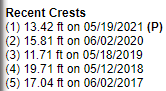

As of today November 16, 2021 the Similkameen River reached 14.37 feet at minor flood stage. It is predicted that the Similkameen has reached its crest and is now decreasing. We are still asking people to stay clear of the Similkameen River.
In comparison to previous years the Similkameen River level was 15.5 feet in 2018, 12.8 feet in 2020. Again, these are predicted levels and could either rise higher or may not reach the levels predicted.

___________________________________________________
2021-11-17
As of today, November 17, 2021 the National Weather Service is advising for continued flooding of the Okanogan River.
To see the current river levels you can view our MAP and click on the red circles for the current gages.
We are in contact with the National Weather Service, they are predicting that the Okanogan River is still rising and near its cresting point of 15.55 feet minor flood stage and will crest mid morning today the 17th. We are asking people to stay clear of the river.
There is still a lot of debris including trees and brush flowing out of the Similkameen into the Okanogan River. There has been debris build-up around some bridges and Okanogan County Public Works has had to remove debris from around the Tonasket Central Street Bridge.
In comparison to previous years the Okanogan River level in 2018 was 19.7 feet and 2020 was 15.8 feet. These are predicted levels and could rise higher or may not reach their predicted level. The water flow is coming down out of Canada.

As of today November 17, 2021 the Similkameen River reached a crest of 14.41 feet minor flood stage yesterday afternoon and is decreasing and currently at 10.92 feet and predicted to drop to 6.9 feet today. We are still asking people to stay clear of the Similkameen River.
In comparison to previous years the Similkameen River level was 15.5 feet in 2018, 12.8 feet in 2020. Again, these are predicted levels and could either rise higher or may not reach the levels predicted.

___________________________________________________
 11/16/2021 South of the Similkameen Trail Bridge
 11/16/2021 Similkameen River backing up the Okanogan
 11/16/2021 Okanogan River South of Oroville
 11/16/2021 Okanogan River South of Oroville